


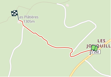
Accès Gîte les Platières

Mariolebeno
User

Length
547 m

Max alt
1303 m

Uphill gradient
40 m
Km-Effort
947 m

Min alt
1259 m

Downhill gradient
0 m
Boucle
No
Creation date :
2024-02-20 16:12:23.395
Updated on :
2024-02-20 16:12:25.326
12m
Difficulty : Very easy

FREE GPS app for hiking
 SityTrail
IGN / Geographical institutes
SityTrail Plus
The world is yours!
About
Trail Walking of 547 m to be discovered at Bourgogne-Franche-Comté, Jura, Septmoncel les Molunes. This trail is proposed by Mariolebeno.
Positioning
Country:
France
Region :
Bourgogne-Franche-Comté
Department/Province :
Jura
Municipality :
Septmoncel les Molunes
Location:
Les Molunes
Start:(Dec)
Start:(UTM)
726470 ; 5137049 (31T) N.
Comments